The international press reported the expansion, from yesterday, 11/04, US Armed Forces Exercises in the Philippines. According to Estadão, these would be “the largest war maneuvers in the history of the Indo-Pacific region”, gathering more than 17 thousand soldiers, and military observers from Japan and Australia off the Spratly Islands, in the South China Sea. The objective would be to monitor the clashes that are being sharpened there, especially in view of the alleged Chinese invasion in the region.. The good relationship of the current Philippine President, Ferdinand Marcos Jr. – son of Ferdinand Marcos who dominated Philippine political life throughout the second half of the 20th century – with the americans, provided the initiative.
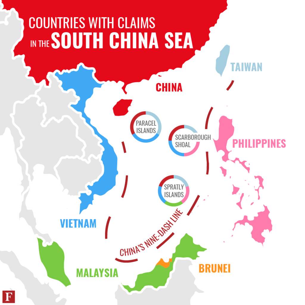
only that…these islands are, together with the Paracel Islands, the two main archipelagos of the South China Sea. They are largely uninhabited., but constitute rich fishing areas, and reportedly may contain significant oil and natural gas reserves. On its ocean floor there is also an abundance of marine life that has been exploited for food by neighboring nations for thousands of years.. Some of the approximately forty-five of these islands, islets and reefs have civil settlements; in all, However, there are structures that were built by Malaysian military forces, Taiwan, China Popular Republic, Philippines and Vietnam. Brunei also postulates its exclusive economic zone in the southeastern part of the Spratly Islands..
All these countries claim some kind of sovereignty over the two archipelagos.. The imbroglio is accentuated due to the “United Nations Convention on the Law of the Sea”, of 1982, which defined and codified themes such as territorial sea, exclusive economic zone and continental shelf, establishing the general principles for the exploitation of its natural resources. In this context, the “Exclusive Economic Zone” (ZEE) defined by the document established the distance of 200 nautical miles (near 370 kilometers) beyond the territorial waters that constitute the 12 miles, or 22 kilometers, from the shore. In these EEZs, the coastal State exercises absolute sovereignty – “sole exploitation rights”, under the terms of the convention – so much about the sea, how much about the air space above, the bottom of the sea and the subsoil below, and has priority in the use and protection of its natural resources.
This is where things get ugly.… The cartographic projections of the two hundred miles of the territorial sea of each of these States invade the spaces of the others, that intersect and compete with each other, making virtually insoluble any isolated claim of univocal right over these territories. to complicate, the Republic of China, based on your perception of history, claims sovereignty over most of the South China Sea as its own. For this, it invokes the so-called “line of nine lanes” (nine-dash line), or line of nine dashes, which was the demarcation initially used by the government of the Republic of China (ROC/Taiwan) and subsequently by the People's Republic of China (RPC) to delimit its territorial sea. The Philippines took its case against Beijing to the International Court of the Law of the Sea, by Hai, in 2016, which unequivocally gave him victory of cause…only the People's Republic never recognized the decision.
But… what is really at stake?
what matters most, as a matter of fact, is the maritime traffic that crosses the region towards the Straits of Malacca, between Indonesia and Malaysia, and opens the way for exports from neighboring countries – including China – destined for the Indian Ocean, and from there to the rest of the planet. In summary, any obstruction of this key passage would cause enormous damage to more than half of the maritime trade in the region.!
And let's include, in addition to this scenario, the struggle for world hegemony between the United States and the People's Republic… and we have the almost perfect storm. Indeed, the maneuver in action is part of a plan launched in 2022 by the Pentagon to expand the American military presence in the region to contain China. Since then, the US installed four new military bases in the Pacific, intensified training, created new alliances and convinced countries in the region to increase their defense spending. in parallel, Americans have extended more incisive support for Taiwan, whose president, Tsai Ing-wen just made a visit to California, where he met with the President – “speaker” – of the House of Representatives, Kevin McCarthy, (remember Nancy Pelosi?…), deeply irritating Beijing, what, as alert, held menacing military exercises off the Taiwan Strait. But, I will address this issue in another post..
In short, for us on this side of the planet, this theme may seem distant and disconnected from our realities. In part, apparently; but only apparently, because the route through the South China Sea, Strait of Malacca is one of the most important sea routes in the world. Near 90 thousand ships per year, or almost 200 ships daily, cross it, making it the main shipping channel between the Indian and Pacific oceans…including for our trade with the region..
In summary: yellow sign!!! , the consequences could be disastrous for all of us!
Hot weather in the South China Sea
The international press reported the expansion, from yesterday, 11/04, US Armed Forces Exercises in the Philippines. According to Estadão, these would be “the largest war maneuvers in the history of the Indo-Pacific region”, gathering more than 17 thousand soldiers, and military observers from Japan and Australia off the Spratly Islands, in the South China Sea. The objective would be to monitor the clashes that are being sharpened there, especially in view of the alleged Chinese invasion in the region.. The good relationship of the current Philippine President, Ferdinand Marcos Jr. – son of Ferdinand Marcos who dominated Philippine political life throughout the second half of the 20th century – with the americans, provided the initiative.
only that…these islands are, together with the Paracel Islands, the two main archipelagos of the South China Sea. They are largely uninhabited., but constitute rich fishing areas, and reportedly may contain significant oil and natural gas reserves. On its ocean floor there is also an abundance of marine life that has been exploited for food by neighboring nations for thousands of years.. Some of the approximately forty-five of these islands, islets and reefs have civil settlements; in all, However, there are structures that were built by Malaysian military forces, Taiwan, China Popular Republic, Philippines and Vietnam. Brunei also postulates its exclusive economic zone in the southeastern part of the Spratly Islands..
All these countries claim some kind of sovereignty over the two archipelagos.. The imbroglio is accentuated due to the “United Nations Convention on the Law of the Sea”, of 1982, which defined and codified themes such as territorial sea, exclusive economic zone and continental shelf, establishing the general principles for the exploitation of its natural resources. In this context, the “Exclusive Economic Zone” (ZEE) defined by the document established the distance of 200 nautical miles (near 370 kilometers) beyond the territorial waters that constitute the 12 miles, or 22 kilometers, from the shore. In these EEZs, the coastal State exercises absolute sovereignty – “sole exploitation rights”, under the terms of the convention – so much about the sea, how much about the air space above, the bottom of the sea and the subsoil below, and has priority in the use and protection of its natural resources.
This is where things get ugly.… The cartographic projections of the two hundred miles of the territorial sea of each of these States invade the spaces of the others, that intersect and compete with each other, making virtually insoluble any isolated claim of univocal right over these territories. to complicate, the Republic of China, based on your perception of history, claims sovereignty over most of the South China Sea as its own. For this, it invokes the so-called “line of nine lanes” (nine-dash line), or line of nine dashes, which was the demarcation initially used by the government of the Republic of China (ROC/Taiwan) and subsequently by the People's Republic of China (RPC) to delimit its territorial sea. The Philippines took its case against Beijing to the International Court of the Law of the Sea, by Hai, in 2016, which unequivocally gave him victory of cause…only the People's Republic never recognized the decision.
But… what is really at stake?
what matters most, as a matter of fact, is the maritime traffic that crosses the region towards the Straits of Malacca, between Indonesia and Malaysia, and opens the way for exports from neighboring countries – including China – destined for the Indian Ocean, and from there to the rest of the planet. In summary, any obstruction of this key passage would cause enormous damage to more than half of the maritime trade in the region.!
And let's include, in addition to this scenario, the struggle for world hegemony between the United States and the People's Republic… and we have the almost perfect storm. Indeed, the maneuver in action is part of a plan launched in 2022 by the Pentagon to expand the American military presence in the region to contain China. Since then, the US installed four new military bases in the Pacific, intensified training, created new alliances and convinced countries in the region to increase their defense spending. in parallel, Americans have extended more incisive support for Taiwan, whose president, Tsai Ing-wen just made a visit to California, where he met with the President – “speaker” – of the House of Representatives, Kevin McCarthy, (remember Nancy Pelosi?…), deeply irritating Beijing, what, as alert, held menacing military exercises off the Taiwan Strait. But, I will address this issue in another post..
In short, for us on this side of the planet, this theme may seem distant and disconnected from our realities. In part, apparently; but only apparently, because the route through the South China Sea, Strait of Malacca is one of the most important sea routes in the world. Near 90 thousand ships per year, or almost 200 ships daily, cross it, making it the main shipping channel between the Indian and Pacific oceans…including for our trade with the region..
In summary: yellow sign!!! , the consequences could be disastrous for all of us!
