A tensão na fronteira entre a Venezuela e a Guiana voltou a ser notícia no último fim de semana, em razão da apreensão, pela marinha venezuelana, dos navios pesqueiros guianenses “Nady Nayera” e “Sea Wolf”. As chancelarias dos dois países trocaram notas de protesto. A Guiana acusa a Venezuela de ter cometido um “ato de agressão” ao apreender os navios em águas guianenses. Os venezuelanos responderam que a apreensão foi legítima, por ter sido realizada em águas sob jurisdição do seu país.
A disputa é anterior à independência dos dois países. Desde o início do século 19, espanhóis e britânicos já disputavam o posicionamento da fronteira entre suas colônias no norte da América do Sul. Em 1835, com a Venezuela já independente, o governo britânico contratou o alemão Robert Schomburgk para mapear a Guiana e definir suas fronteiras. Ao terminar o trabalho, a fronteira havia sido definida nas alturas da foz do Rio Orinoco. Os venezuelanos protestaram afirmando que o local legítimo para a delimitação da fronteira era o Rio Essequibo. Iniciaram-se negociações entre os dois lados, que não foram capazes de criar um consenso. Em 1850, os dois lados concordaram em não ocupar a área contestada.
A descoberta de ouro na região reascendeu a disputa. Colonos britânicos penetraram na área e foi criada uma companhia mineradora britânica, para explorar as minas de ouro. A Venezuela protestou seguidas vezes, propondo aos ingleses uma arbitragem, mas estes nunca se mostraram interessados. Até que, em 1887, a Venezuela rompeu as relações diplomáticas com a Inglaterra e pediu ajuda diplomática aos EUA. Assim, em 1897, sob pressão norte-americana, finalmente os ingleses concordaram em submeter a disputa à arbitragem internacional.
Por dois anos a comissão arbitral, formada por dois britânicos, dois norte-americanos (indicados pelo lado venezuelano) e um russo, se debruçou sobre o assunto e decidiu, em 1899, por conceder 94% do território em disputa à Guiana. Aos venezuelanos foi cedida uma área na foz do Rio Orinoco e uma pequena área junto ao Atlântico. Apesar da insatisfação venezuelana com o resultado, os dois lados aceitaram o acordo em 1905. Por sessenta anos, a situação permaneceu pacificada.
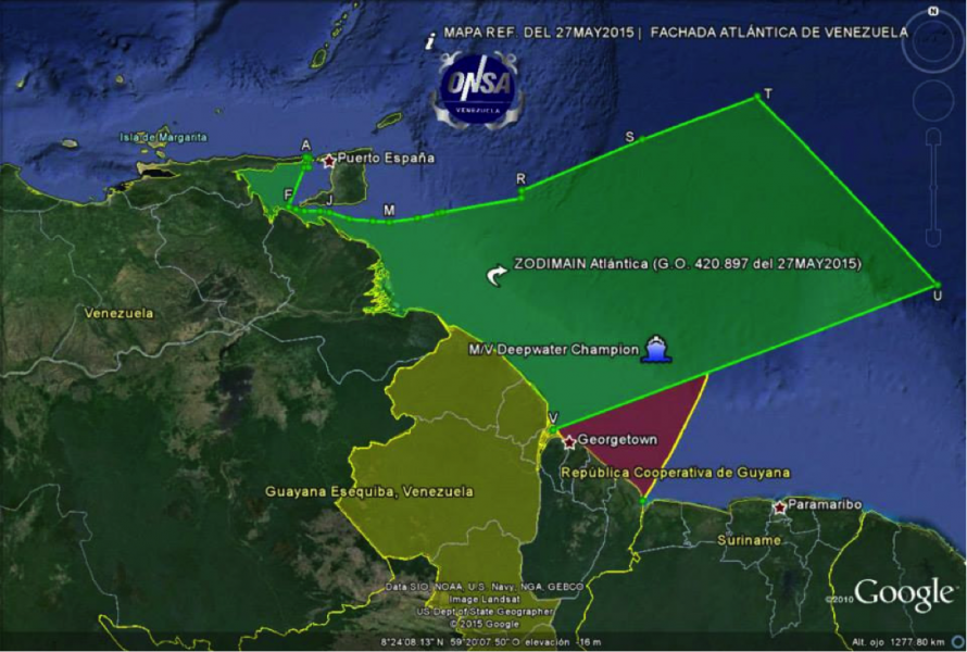
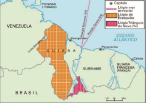
Em 1962 os venezuelanos apresentaram uma série de argumentos para colocar em xeque a imparcialidade da comissão arbitral de 1889, declarando junto à ONU que considerava nula aquela resolução, colocando toda a região a oeste do Rio Essequibo como “Zona em Reclamação” do território venezuelano, assim fazendo constar nos mapas oficiais do país. Trata-se de uma área de cerca de 159.500 Km2, ou 5/8 do atual território guianense.

Fonte – Gutemberg V Silva, 2015
A tentativa de revisão venezuelana ocorreu em um momento em que a Guiana ainda era uma colônia inglesa, mas já se antevia sua independência. Os venezuelanos calcularam à época, com razão, que seria mais fácil obter um acordo com os ingleses, afinal se tratava de uma área em uma colônia distante, do que com uma nação independente que, caso a aspiração venezuelana fosse atendida, perderia mais da metade de seu território.
Ainda assim, uma nova comissão para tentar resolver o problema só foi instalada em 1966, por meio do chamado Acordo de Genebra. A comissão mista teria um prazo de quatro anos para resolver a questão. Apenas três meses depois, a Guiana se tornou independente. Mas uma série de incidentes fronteiriços impediram o avanço dos trabalhos. Em 1970, terminou o prazo para os ofícios da comissão, e nenhum acordo foi possível. Os dois países, então, assinaram um novo protocolo, congelando a situação vigente em mais doze anos.
A partir de então, já na década de 1980, a ONU passou a intermediar a disputa e, embora não se tenha chegado a uma solução para a questão, as relações entre os dois países se normalizaram, com incidentes ocorrendo esporadicamente. As sucessivas mudanças de governo, tanto na Venezuela quanto na Guiana, proporcionaram momentos de maior ou menor tensão nas relações entre os dois países.
Em 2015, a descoberta de grandes reservas de petróleo pela empresa Exxon acrescentou um novo e importante atrativo à região, reacendendo a disputa.
Em janeiro de 2018, o Secretário Geral da ONU deu por esgotadas as possibilidades de intermediação e indicou que a Corte Internacional de Justiça (CIJ) seria o foro competente para solucionar a questão. Assim, em março de 2018, a Guiana solicitou a jurisdição da CIJ para que validasse o acordo de 1899. O país alegou que se esgotaram as possibilidades de conciliação por intermédio do Acordo de Genebra. A Venezuela se manifestou contrariamente à posição guianense, mas, em dezembro de 2020, a Corte declarou que possuía jurisdição para deliberar sobre o assunto[1].
Em reação, no dia 8 de janeiro deste ano, a Venezuela estabeleceu a chamada “Zona de Desenvolvimento Estratégico da Fachada Atlântica” que “protegerá e salvaguardará a jurisdição de seus espaços continentais, interiores, limítrofes, áreas marinhas históricas e vitais do país.” Trata-se de uma medida unilateral, que cria um território marítimo, como uma medida para reafirmar a soberania sobre as águas territoriais contíguas à área reclamada.
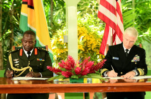
No dia seguinte, em 9 de janeiro, os EUA e a Guiana realizaram um exercício naval combinado na costa guianense. Um navio patrulha da Guarda Costeira norte-americana adestrou-se junto a outros navios-patrulha do país sul-americano. Dois dias depois, o Almirante Craig S. Faller, Comandante do Comando Sul dos EUA, esteve na Guiana para firmar um acordo de cooperação militar com as Forças de Defesa do país. Recentemente, os EUA já haviam doado motores e peças de reposição para navios guianenses de patrulha.

Fonte – Jornal Guyana Chronicle
A Venezuela protestou pela presença de navio armado norte-americano nas proximidades de seu território, bem como pela presença de Faller na Guiana.
Neste cenário, ocorreram as últimas apreensões dos navios pesqueiros e tripulantes guianenses pela marinha venezuelana. O governo Maduro sabe que a CIJ dificilmente chegará a uma decisão que lhe seja favorável, pois isso significaria para a Guiana a perda de 5/8 de seu território, o que lhe inviabilizaria como nação soberana. Além disso, a perda territorial ocorreria no momento em que as descobertas petrolíferas recentes representam uma esperança de mudança de patamar econômico para uma nação tão pobre como a Guiana.
Os próximos acontecimentos dependem da decisão da Corte Internacional de Justiça. Se a Corte decidir pela validade do acordo de 1899, o assunto estará encerrado no campo diplomático – pelo menos por enquanto – e a liberdade de ação da Venezuela neste assunto estará muito mais restrita.
Mas, no momento em que a Venezuela enfrenta uma crise política, econômica e social sem precedentes, o antigo recurso dos governos, de recorrer a uma questão externa que una a população em torno de uma causa nacionalista, tirando o foco dos problemas internos, é sempre tentador.
[1] https://www.icj-cij.org/public/files/case-related/171/171-20201218-PRE-01-00-EN.pdf
Oficial de cavalaria do Exército, formado na Academia Militar das Agulhas Negras, em 1990. Foi comandante do 11º Regimento de Cavalaria Mecanizado, em Ponta Porã/MS; instrutor da Academia Militar das Agulhas Negras, da Escola de Aperfeicoamento de Oficiais e da Escola de Comando e Estado-Maior do Exército.
Atualmente serve no Comando de Operações Terrestres – COTER – em Brasília/DF.
Os artigos publicados são de opiniões pessoais. Não fala em nome do Exército. As ideias aqui expressas são fruto da sua experiência profissional e dos estudos que realizou.
